Whiterock and the Western Rim
Contents
During previous walks at the northern end of the Bogong High Plains we’d noticed a knoll between Timms Spur and Whiterock Creek and wondered about camping there. It was an attractive spot: water was within reach and its elevation gave extensive views. The only downside was that it was quite exposed, despite some tree cover.
Interminable COVID-19 lockdowns gave us plenty of time to make plans for a four day walk using Whiterock Knoll (as we called it) as a base. By the time we were able to get out the weather forecast was less than ideal, with a storm predicted for what would have been the fourth day. Not wanting to defer the walk any longer, we compressed it down to three days. The only significant impact was a considerably longer first day.
Hilltops and Whiterock

After the long drive from Melbourne — punctuated by a stop at Mount Beauty to acquire some lunch and a snack — Dad and I arrived at the Watchbed Creek trailhead about noon, close by the glittering blue waters of the Rocky Valley Dam.
Since last we were here a couple of years ago there had been an unwelcome change. The start of the fire trail used to be open to traffic for a kilometre or so to a gate where you could park, but now that’s been brought back almost to the main road. Not only does that give an extra kilometre of road walking, it’s also reduced the space available for parking, though surprisingly that wasn’t an issue today with only two other cars there.
We started walking along the Big River fire trail, favoured with sunshine and a pleasantly cool breeze. The trail soon entered a forest of snow gums as it climbed steadily upwards, the thick vegetation blotting out the views. At least without any distractions we set a good pace, and the trees gave a little shade when we wanted to rest.
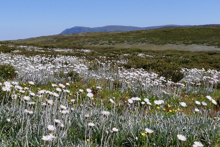
We emerged from the forest to open plains near the upper end of the Watchbed Creek valley, and the gradient eased around the same time. Spread through the grass were drifts of silver daisies, their white flowers and silver-green foliage bright against the grass. The ridges were fringed with dead snow gums, the relics of past fires.
 It was the perfect time of year for silver daisies.
A little further along was the junction with the track heading east over to Fitzgeralds Hut and Kellys Hut. This marked the departure from our original plan, which had been to spend the first night at Fitzgeralds Hut then continue on to Whiterock Knoll the next day. Needing to save one day we’d decided to skip the hut and head straight to the knoll.
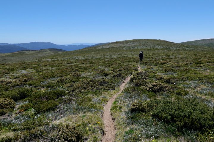
Before us the trail wound its way over a small rise. As we crested it the views opened up to the north across the green rolling hills. Straight ahead of us and a couple of kilometres away rose Mt Nelse, a slightly taller green hill amongst other green hills. The course of the trail was plain to see on its western side.
 Hollonds Knob.
A short way along we reached the junction with the Heathy Spur track and took a break. We sat in the lee of the signpost to escape the breeze while we ate our lunch. Heathy Spur would have been a much prettier option for walking in than the way we chose, however it’s also considerably longer and our day was already pushing the limits of what we had time to do.
We ate our lunch under a bright blue sky. Kestrels hovered above the plains, while down among the scrub and silver daisies were masses of little blue butterflies. Patches of tiny pale yellow flowers provided a contrast with the green grass.
The trail continued on, curving across the low hills to the base of Mt Nelse, then climbing the western side of the peak to a saddle at the top of Baker Spur, somewhat to the northwest of the actual summit. As we gained elevation we could see further to the west: The Fainters, Feathertop, and Buffalo. We also met our first other walker for the day, a lady heading the other way who’d come from Mt Bogong, though whether she was camping or just doing daywalks wasn’t clear as she wasn’t carrying much gear.
Keeping fit during the lockdowns had paid off as we’d managed a good pace up what is a fairly solid climb. At the saddle we rested for a while. A foot pad led off southeastwards to the summit of Mt Nelse, and we followed it to the summit cairn. The trig that used to be here blew down several years ago.
 The foot pad leading to the summit of Mt Nelse.
 On top of the world: approaching the summit of Mt Nelse.
Mt Nelse is the fifth highest peak in Victoria at 1,882 metres, slightly lower than both its nearby northern sibling (1,884 metres) and Mt Steadfast1 just to the northwest (1,893 metres). The views were fantastic, uninterrupted in all directions: eastward range upon range faded to the horizon, southwest were glimpses of the high plains, to the west were some of the major peaks of the Victorian Alps, and northward Mt Bogong peeped over the shoulder of Mt Nelse North.
The Nelses aren’t spectacular peaks themselves, shaped more like hills. But there’s something about them, the massive scale of the landscape combined with the huge skies and endless views, that gives the feeling of high elevation.
Being so exposed the Nelses are often quite breezy, and today was no exception, though with some warming sunshine it was a pleasant spot to take a break. While we stood there we saw two people returning from Mt Steadfast along the Spion Kopje fire trail towards Warby Corner, then turn northwards towards Ropers Hut. We weren’t alone up here, but it was surprisingly quiet.
 The view from near Mt Nelse: the twin peaks of The Fainters, Mt Buffalo, and the Spion Kopje spur.
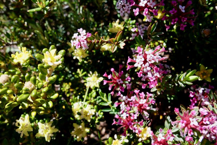 From a distance the land appears plain green, but look closer and there are flowers everywhere.
Between Nelse and Nelse North is open with a mix of grass and rocks, and we set off cross-country heading straight to northern summit. Studded through the grass and were masses of flowers: silver daisies, heath with little white stars, tiny pink and white alpine rice-flower, bright yellow buttercups, and pale yellow alpine stackhousia.
At the Mt Nelse North summit trig marker we stopped briefly to admire the views. The saddle north of here holds its snow longer than just about anywhere else in the vicinity. In past years we’ve seen snow here in late January. Last winter must have been a lean season though, as today (early December) there were only a few small drifts left.
 The remains of winter snow in the saddle beyond Mt Nelse North. The impact of the long-lasting snow on the vegetation is plain to see.
Moments after leaving the summit I realized that the end of my drinking tube had gone and water was draining out. But despite both of us searching for at least five minutes neither of us could spot it, even though it was bright blue and must have been within metres of where we were standing. An annoying thing to happen, and a lesson learned: nowadays I keep spare end-pieces in my emergency repair kit.
The descent to the saddle isn’t far but is fairly steep. We rejoined the fire trail and pushed on. The afternoon was wearing away and, even with the long summer daylight, we needed to keep going.
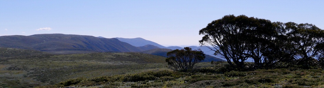
The trail skirted the headwaters of Whiterock Creek, which dropped away on our left to the northwest. At the junction with the Ropers Hut track we took the left branch, heading towards Timms Spur. On our right we passed a large patch of marshy ground which forms the source of the creek that flows below Ropers Hut. Our objective was now clear in front of us, the knoll with its fringe of trees.
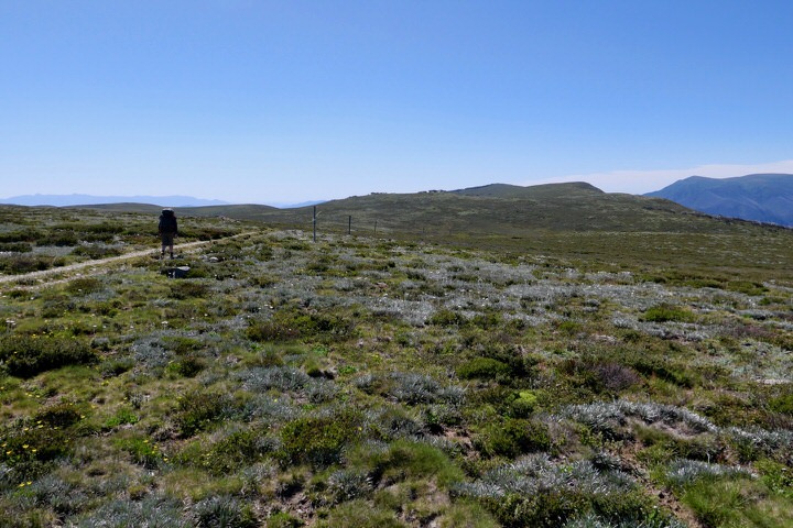 The road to Whiterock Knoll. The trees on the horizon mark its summit.
The trail approached the knoll then swung north to sidle across its eastern flank. We left the trail here and headed slowly up to the summit of the knoll which stands at 1,790 metres. We’d covered 11·3 km and ascended 430 metres, a decent effort for an afternoon.
Our previous reconnaissance had left me confident there were plenty of campsites, but my memory may have taken on a rose-tinted view of the area. Our options were few after factoring in the weather forecast for strong winds from the western quarter. After some consideration we selected a site just over the western side of the knoll. Although this was the windward side, there were more trees on this side to act as a windbreak. We tucked the tents in close to the trees, and I added extra guys to my tent as protection against the weather, leaving it as tight as a drum.
 Arriving at the crown of Whiterock Knoll.
It was now late afternoon with dinner still to be cooked, but first we needed water. Whiterock Creek made its closest approach to our camp to the southwest but that involved a big drop. Heading straight south traded a slightly longer walk for less descent and ascent. The creek was quite beautiful, meandering back and forth across the floor of the valley in its stony bed, bordered by heaths and mosses. Beside it were many flat patches of grass that would make lovely campsites when the weather is kind.
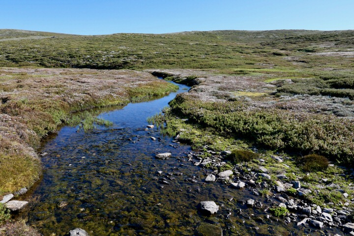 Whiterock Creek.
We made our dinner up on the very top of the knoll where we found an existing fireplace. It was a nice area, with convenient rocks for seats and great views. It was a favourite with the butterflies too, with a variety flitting around to bask in the evening sun on trees and rocks.
While we ate we discussed our options for the walk. Dad had the idea of modifying our last day to make it more interesting: instead of retracing our route along the fire trail we could head cross-country to Mt Steadfast, giving us more off-track walking and another peak to bag. And if the forecast happened to clear up for the fourth day we could stay out an extra day and head over to the site of Battys Hut.
 Sunset at Whiterock Knoll.
Half an hour before sunset we were all done with dinner, so we strolled across the hilltop in search of a clear view of the western horizon. With no cloud in the sky there wasn’t much colour in the sunset, just a golden glow on the horizon as the sun dipped. After a long day we were both glad to retire to our tents to sleep.
The Western Rim
Soon after getting into my tent I discovered that I’d pitched it on both a down-slope and a cross-slope, and on some of the lumpiest ground I’ve camped on. Despite repeatedly waking to find myself having slid down to the bottom of the tent, I eventually found a comfortable space amongst the lumps and had a decent night.
I got up about an hour before midnight. A haze clung to the land, dulling the stars. A bright pink glow on the eastern horizon soon revealed itself to be the moon rising through the haze. The wind was only light so I stayed up a while to admire the scene, and caught sight of a shooting star streaking southwards at tremendous speed.
 The night sky above the high plains.
The moonlight set off the insects that had gathered between my tent’s inner and fly, and they rattled away for hours. As dawn neared the wind began to rise, seething through the trees. I could hear the roar of each blast working its way up the valley towards our camp. Little of it struck our tents, however, so we must have chosen our site well.
The morning dawned clear, cool, and breezy. Our plan for the day was to visit the Crowsnest and Spion Kopje. After breakfast we started down to Whiterock Creek. The hillsides were covered with daisies, fragrant alpine mint bush, prickly heaths, eyebright, and a sprinkling of small violets in white, mauve and purple. None of the scrub was more than shin-high so the walking was excellent and we could go wherever we fancied.
 Our tents nestled amongst the trees.
The creek was small enough to cross without much trouble. Continuing south we climbed over the low ridge that divides this valley from the next. Following the shape of the land we headed southwest along a shallow gully and dropped down to the headwaters of Big River.
 Heading down to Big River. Feathertop looms large to the southwest.
The embryonic river was populated by small finger-sized fish2 with a very nervous temperament that hid themselves under the banks at the slightest disturbance. It’s a wonder they’re able to survive up here in such small waterways in an area that’s heavily snow-bound in winter, and cut off from the lowlands by waterfalls further downstream3.
Across the river was the old aqueduct and the Spion Kopje fire trail, and we followed them westward towards Spion Kopje. The daisies were in abundance, blazes of white flowers spread like snow drifts across the rolling grassland. Above them rose Mt Bogong, clearly to be seen now we were gaining altitude. A tan-coloured kestrel passed overhead, ignoring us completely: we were too big to eat, and didn’t rate as a threat.
 Silver daisies covered the plains.
After a couple of kilometres we reached the signpost for the junction with the Grey Hills track, though there was no hint of the track itself. We made our own way towards the obvious ridge leading on to the Crowsnest, initially following a tiny stream that rose out of the grass. Lower down where the scrub increased a track emerged. Surprisingly it had been slashed in the recent past.
As we descended towards the Crowsnest, the Big River valley on our right cut deeper and deeper, separating the peak from the plains. The tiny river we’d crossed earlier had already grown considerably, and leapt down from the plains in a series of cascades and waterfalls. By the time it swept past the foot of the Crowsnest it was already over a hundred metres below us.
From humble beginnings Big River does live up to its name. After the valley here passes out of sight to the north-northwest, the river turns sharply to the east in a deep valley 800 metres below the plains, isolating Mt Bogong. Finally it turns again, swinging round to the south to bound the eastern side of this area.
 The Crowsnest. To its right is the Big River valley and the high plains.
 Just a couple of kilometres from its source Big River has already carved an impressive valley.
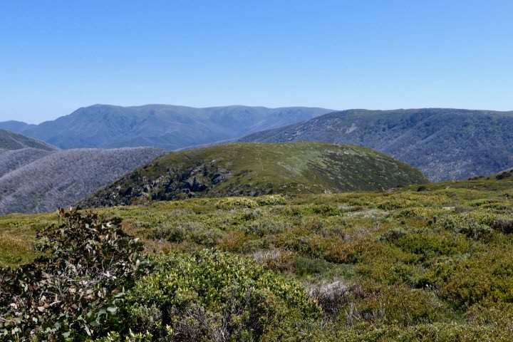
We reached the broad summit of the Crowsnest mid-morning and had a snack while we rested. From our vantage point at around 1,740 metres we had our best view yet of the impressive Big River valley. Half a kilometre downstream another creek cascaded off the high plains to feed into Big River. Behind us the Spion Kopje ridgeline dominated the horizon.
We retraced our route back up to the fire trail. This time we found a few cairns in the untracked upper part of the climb where they stood out against the horizon, though there was no path to go with them.
Back on the fire trail we continued west towards Spion Kopje, now less than a kilometre away. The fire trail passes the summit a hundred or so metres to its north, so we headed off across the grass and low scrub for the last stretch to the summit proper at 1,841 metres.
Despite the sunshine there was a cold wind blowing, and we sought a spot with some shelter for our lunch break, also taking care to avoid the abundant ant nests. The spot we chose was close to the actual summit, a little way above the trig marker which, strangely, is situated downhill to the southwest.
 The Spion Kopje trig marker. The looseness of the wires bracing the marker suggest it may not survive much longer.
Spion Kopje stands at the far western extremity of this part of the high plains. The summit is clear so the views are brilliant, spanning many peaks of the Victorian Alps: Feathertop, the Fainters, and Buffalo. Northward was Bogong and the western rim of the high plains. To the south was Falls Creek and the Rocky Valley Dam.
We began our return back along the fire trail, an easy walk since it was generally downhill. After a couple of kilometres we left the trail where it curved away southeast to strike out cross-country in a more direct line northeast back to our camp. After dropping down a short slope we crossed Big River, still small this high up, then climbed back up to the plains.
This area over near the western edge of the plains was particularly beautiful. Drifts of silver daisies and patches of heath were scattered across the gently rolling land, with excellent views from Mt Buffalo around to Mt Bogong. Somewhat unusually for this area there was no sign of human influence on the land: no fire trails, aqueducts, or walking tracks.
 Crossing Big River.
 The western edge of the plains.
We strolled along under the vast sky, across grassland dusted white with flowers. Whiterock Knoll was in sight intermittently, and we set course straight towards it. We reached the creek downstream of where we’d crossed it this morning. It had begun to cut itself a distinct little valley, with heath-fringed pools sitting beside the main watercourse. The stream was now large enough to support a population of fish and we spotted a few darting for cover. To save returning later we took the opportunity to refill our water supply.
 A green scarab beetle on candle heath down by Whiterock Creek.
The climb up to camp was rather steep (accentuated by our increased load of water), the knoll being much higher than the plains we’d crossed. It was with some relief we reached our tents. Our shortcut had saved about 1·5 km compared to our outward route, with the day’s walk coming in at 12·9 km with 515 metres ascent.
It was early afternoon. The tent was very hot from being in the sun, so I opened it up to ventilate while I made a second (cooked) lunch. Both Dad and I were feeling tired so we snoozed for a while.
I had plans to follow Whiterock Creek downstream to where I thought I’d find some waterfalls. Feeling restored from my snooze I set off alone. I headed back down to the creek, angling more to the southwest this time (and more steeply downhill) to hit the creek further downstream. I reached it at a picturesque cascade with a small fall over multiple levels of rock.
Downstream the creek followed a zigzag course in the shallow but steep-sided valley. I followed it down, needing to head up near the rim of the valley in places. Back down near the water again I clambered over tumbled boulders and then through thick scrub… which was when I wished I’d remembered to bring my gaiters. I wasn’t going to go back for them, but I did start thinking about snakes lurking in the scratchy scrub.
 Whiterock Creek on its way to join Big River.
All the way along the course of the creek were small cascades and falls. The bare alpine meadows had given way to snow gum forest. The struggle through the scrub was becoming tiring, and there was no sign of the large falls I’d been hoping to find. Looking at the map suggested I wasn’t far from them, no more than a hundred metres, so I persevered. It was well worth it: I came upon a huge cascade about forty metres high plummeting down to a pool deep within a gorge.
From the top I could see the full height of the cascade down to the pool at its base. I briefly entertained thoughts of trying to reach the pool, but realistically I didn’t have time to scramble down the steep, loose slope. I could easily have spent a whole day exploring this creek. So I went as far as I could, and enjoyed the view I had.
 Whiterock Creek cascading down to a pool.
 A small cascade on Whiterock Creek. On the left near the surface of the water is a mountain galaxia.
Turning around I began the walk back to camp, switching to the other side of the creek for some variety. Now heading uphill I gained an appreciation for just how far I’d dropped below the campsite.
When I got back to camp it was time for dinner. Without the time pressure of yesterday it was a more relaxed affair. Once again our cooking area was visited by a variety of butterflies as the sun dropped in the sky, while grasshoppers hidden in the grass chirped and buzzed.
 Australian painted lady.
 Australian admiral.
Our campsite was high enough to have phone reception which meant we were able to check the weather forecast. Our hopes of being able to extend the walk back to four days were dashed, as the forecast had deteriorated to be both wetter and windier.
But for now the sky was very clear. This made for a pleasant evening, but also make it unlikely we’d get a colourful sunset, so we headed off to bed early.
Before the Storm

Once again I got up by chance just as the moon was rising, about midnight this time. The stars were brighter than last night so I spent a while enjoying the sight of both them and the rising moon.
 Moonrise at Whiterock Knoll.
Back in the tent I wasn’t able to get back into a comfortable spot amongst the lumps, so I didn’t have a particularly good sleep. The wind began to build as the dawn approached, once again roaring up the valleys and through the trees. Our luck held as our tents continued to be fairly well sheltered from the wind, which had changed direction as the predicted storm approached.
With the arrival of dawn we packed up everything inside our tents before stepping out into the cold morning air for breakfast. Some of the cloud that had built up earlier seemed to have lessened, but the cold wind was still blowing.
We completed our packing up. I suffered from the usual problem of my pack seeming more full than when I started. We were off reasonably early and followed more or less the same route down to the creek as yesterday morning. After crossing the creek we angled to the left to aim for the summit of Steadfast. It was easy walking, despite the uphill gradient, and had the familiar daisies, mint bush, heath, and violets.
 Pools beside the main stream in the Whiterock Creek valley.
 At the summit of Mt Steadfast, the highest point of our walk at 1,893 metres.
At the very exposed summit of Mt Steadfast we had the usual cold wind. The pale sunlight did little to counteract the chill. The trig here is offset from the true summit, as with Spion Kopje, and it had lured us the wrong way before we discovered our mistake. Befitting the third highest peak in Victoria, the views were wonderful in all directions. Much of the route of our walk was in sight, including most of the plains we’d crossed yesterday, with glimpses down the Whiterock Creek valley.
We were now at the highest point of the entire walk, so most of the hard work was done for the day. We set off down to Warby Corner, then followed the fire trail across the side of the Nelses. At the saddle where the Nelse summit foot pad takes off we met a group of four cyclists, the first people we’d seen for a couple of days.
This saddle marked the point where we started to retrace our first day’s route. We followed the trail down the southern flank of Mt Nelse, past the junctions of the side tracks to Edmondsons and Johnstons Huts, and on to the junction with the Heathy Spur track.
 Descending from Mt Nelse towards The Park, with Hollonds Knob and Marum Point on the horizon.
We met a pair of walkers here and chatted for a while. They’d been staying at Falls Creek for a few days and heading out for daywalks. Like us they were surprised at how few people were around. I’d imagined that with the lifting of lockdown people would be bursting to get out to the wilds.
And so began the last leg of the walk as we continued along the trail to Watchbed Creek, then down to the trailhead. It was a dull section, especially the last kilometre or so. The sun had brightened and our descent into the snow gum forest had cut off the breeze, so we started to feel quite warm. We were back to the car by noon, having covered 10·4 km and ascended a moderate 200 metres.
We’d managed to pack quite a lot into our three days. And while it was disappointing to trim a day from the walk, our decision proved to be well justified. We hadn’t got far on our drive back to Melbourne before the rain started pattering down. Soon it was pouring, driven by strong winds. The next day, which would have been our fourth, was even colder, wetter, and windier. As beautiful as those high plains are, they’re no place to be in wild weather.
Footnotes
- This peak, the third highest in Victoria, has no official name despite being the highest in the vicinity. Unofficial names include Mt Steadfast and Mt Nelse West. ↩︎
- The fish are a species of mountain galaxia. ↩︎
- Some mountain galaxias are able to climb past barriers (see the Wikipedia entry for Mountain Galaxias), however both Whiterock Creek and Big River have large falls so I’m inclined to think the fish in the headwaters of these streams are captive. ↩︎
